Follow My Trip

S&P 500 7,509.20 ▲ +0.89%
Nasdaq 25,837.21 ▲ +1.29%
Dow 52,224.64 ▲ +0.74%
92° Chance Showers And Thunderstorms

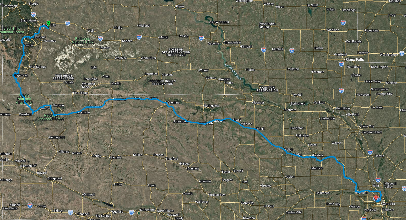
Map of my next trip

Route Map · 660 miles
Next trip route map

This year's ride is a 660-mile (1,060 km) journey from Rapid City, South Dakota east to Omaha, Nebraska. The route drops out of the Black Hills, crosses the wide-open Nebraska Sandhills, and follows the historic Cowboy Trail corridor down the Elkhorn Valley before reaching the Missouri River. Overall it loses roughly 2,000 feet of elevation from the high country to the plains, so the general trend runs downhill and eastbound — often with a helpful prevailing tailwind.

  • 1 · Black Hills — Rapid City to Edgemont

    The ride starts on the edge of Black Hills National Forest and picks up the George S. Mickelson Trail, climbing through pine-covered ridges past Custer, near Wind Cave, and down to the resort town of Hot Springs before reaching Edgemont in the far southwest corner of South Dakota. Expect the most sustained climbing of the trip here.

  • 2 · Pine Ridge & Oglala National Grassland — Edgemont to Chadron

    Crossing into Nebraska, the route threads the Oglala National Grassland and the rugged Pine Ridge escarpment, passing near Fort Robinson and Crawford before rolling into Chadron. Buttes, ponderosa pine, and big open range replace the forest.

  • 3 · The Sandhills — Chadron to Valentine

    This is the heart of the trip: mile after mile of grass-covered dunes through Rushville, Gordon, Merriman, and Cody. Towns and services are far apart, so it's remote, quiet riding all the way to Valentine on the Niobrara River.

  • 4 · Cowboy Trail & Niobrara Valley — Valentine to O'Neill

    From Valentine the route follows the corridor of the Cowboy Recreation and Nature Trail — a converted rail-trail of crushed limestone and restored railroad bridges — east through Ainsworth, Bassett, Stuart, and Atkinson to O'Neill, the "Irish Capital of Nebraska."

  • 5 · Elkhorn Valley — O'Neill to Norfolk

    Turning southeast, the countryside shifts to rolling farmland along the Elkhorn River, passing through Neligh and Tilden into Norfolk, the largest town of the second half.

  • 6 · Final Run to Omaha — Norfolk to the Missouri River

    The home stretch rolls through Madison and Fremont before joining the Missouri River valley and finishing in the Omaha metro at the red marker on the map.

Two great rail-trails

Mickelson & Cowboy

This route is built around two of the best rail-trails in the country — converted railroad grades with gentle gradients, crushed-limestone surfaces, and dozens of restored trestle bridges. One carries me out of the Black Hills, the other across northern Nebraska.

  • George S. Mickelson Trail (South Dakota)

    South Dakota's first rail-trail runs 109 miles from Deadwood to Edgemont along the old Deadwood Central / Burlington Northern grade through the heart of the Black Hills. It features four rock tunnels and more than 100 converted railroad bridges, with 15 trailheads along the way. Built for trains, its grades rarely exceed 4%, though it still climbs to roughly 6,000 feet near Dumont — the high point of the whole trip. The surface is crushed limestone and gravel, and a daily or annual trail pass is required. It's named for former Governor George S. Mickelson.

  • Cowboy Recreation and Nature Trail (Nebraska)

    The "Cowboy Trail" follows the former Chicago & North Western line across northern Nebraska. Around 195+ miles are open from Norfolk west to Valentine (and beyond), with the full vision reaching some 321 miles to Chadron — which would make it one of the longest rail-trails in the United States. Its signature landmark is the quarter-mile bridge over the Niobrara River near Valentine, standing about 150 feet above the water. The crushed-limestone path rolls through the Sandhills and is a key link in the cross-country Great American Rail-Trail.