Atlantic
Title |
Description |
Atlantic Tropical Weather Outlook |
066 ABNT20 KNHC 242314 TWOAT
Tropical Weather Outlook NWS National Hurricane Center Miami FL 800 PM EDT Tue Jun 24 2025
For the North Atlantic...Caribbean Sea and the Gulf of America:
Active Systems: The National Hurricane Center is issuing advisories on Tropical Storm Andrea, located in the central subtropical Atlantic.
Tropical cyclone formation is not expected during the next 7 days.
&& Public Advisories on Tropical Storm Andrea are issued under WMO header WTNT31 KNHC and under AWIPS header MIATCPAT1. Forecast/Advisories on Tropical Storm Andrea are issued under WMO header WTNT21 KNHC and under AWIPS header MIATCMAT1.
$$ Forecaster Papin |
Summary for Post-Tropical Cyclone Andrea (AT1/AL012025) |
...ANDREA BECOMES A REMNANT LOW... ...THIS IS THE FINAL ADVISORY... As of 11:00 PM AST Tue Jun 24 the center of Andrea was located near 38.7, -45.2 with movement ENE at 20 mph. The minimum central pressure was 1015 mb with maximum sustained winds of about 35 mph. |
Post-Tropical Cyclone Andrea Public Advisory Number 3 |
Issued at 1100 PM AST Tue Jun 24 2025 617
WTNT31 KNHC 250244
TCPAT1
BULLETIN
Post-Tropical Cyclone Andrea Advisory Number 3
NWS National Hurricane Center Miami FL AL012025
1100 PM AST Tue Jun 24 2025
...ANDREA BECOMES A REMNANT LOW...
...THIS IS THE FINAL ADVISORY...
SUMMARY OF 1100 PM AST...0300 UTC...INFORMATION
-----------------------------------------------
LOCATION...38.7N 45.2W
ABOUT 985 MI...1585 KM W OF THE AZORES
MAXIMUM SUSTAINED WINDS...35 MPH...55 KM/H
PRESENT MOVEMENT...ENE OR 60 DEGREES AT 20 MPH...31 KM/H
MINIMUM CENTRAL PRESSURE...1015 MB...29.98 INCHES
WATCHES AND WARNINGS
--------------------
There are no coastal watches or warnings in effect.
DISCUSSION AND OUTLOOK
----------------------
At 1100 PM AST (0300 UTC), the center of Post-Tropical Cyclone
Andrea was located near latitude 38.7 North, longitude 45.2 West.
The post-tropical cyclone is moving toward the east-northeast near
20 mph (31 km/h) and this motion is expected to continue until the
circulation opens up into a trough.
Maximum sustained winds have decreased to near 35 mph (55 km/h) with
higher gusts. Additional weakening is expected and the remnant low
is expected to degenerate into a trough l.
The estimated minimum central pressure is 1015 mb (29.98 inches).
HAZARDS AFFECTING LAND
----------------------
None.
NEXT ADVISORY
-------------
This is the last public advisory issued by the National Hurricane
Center on this system. Additional information on this system can be
found in High Seas Forecasts issued by the National Weather Service,
under AWIPS header NFDHSFAT1, WMO header FZNT01 KWBC, and online at
ocean.weather.gov/shtml/NFDHSFAT1.php
$$
Forecaster Papin |
Post-Tropical Cyclone Andrea Forecast Advisory Number 3 |
Issued at 0300 UTC WED JUN 25 2025 350
WTNT21 KNHC 250244
TCMAT1
POST-TROPICAL CYCLONE ANDREA FORECAST/ADVISORY NUMBER 3
NWS NATIONAL HURRICANE CENTER MIAMI FL AL012025
0300 UTC WED JUN 25 2025
POST-TROPICAL CYCLONE CENTER LOCATED NEAR 38.7N 45.2W AT 25/0300Z
POSITION ACCURATE WITHIN 30 NM
PRESENT MOVEMENT TOWARD THE EAST-NORTHEAST OR 60 DEGREES AT 17 KT
ESTIMATED MINIMUM CENTRAL PRESSURE 1015 MB
MAX SUSTAINED WINDS 30 KT WITH GUSTS TO 40 KT.
4 M SEAS.... 0NE 0SE 60SW 0NW.
WINDS AND SEAS VARY GREATLY IN EACH QUADRANT. RADII IN NAUTICAL
MILES ARE THE LARGEST RADII EXPECTED ANYWHERE IN THAT QUADRANT.
REPEAT...CENTER LOCATED NEAR 38.7N 45.2W AT 25/0300Z
AT 25/0000Z CENTER WAS LOCATED NEAR 38.3N 45.7W
FORECAST VALID 25/1200Z 40.1N 41.1W...POST-TROP/REMNT LOW
MAX WIND 25 KT...GUSTS 35 KT.
FORECAST VALID 26/0000Z...DISSIPATED
REQUEST FOR 3 HOURLY SHIP REPORTS WITHIN 300 MILES OF 38.7N 45.2W
THIS IS THE LAST FORECAST/ADVISORY ISSUED BY THE NATIONAL HURRICANE
CENTER ON THIS SYSTEM. ADDITIONAL INFORMATION ON THIS SYSTEM CAN BE
FOUND IN HIGH SEAS FORECASTS ISSUED BY THE NATIONAL WEATHER
SERVICE...UNDER AWIPS HEADER NFDHSFAT1 AND WMO HEADER FZNT01 KWBC.
$$
FORECASTER PAPIN |
Post-Tropical Cyclone Andrea Forecast Discussion Number 3 |
Issued at 1100 PM AST Tue Jun 24 2025 404
WTNT41 KNHC 250245
TCDAT1
Post-Tropical Cyclone Andrea Discussion Number 3
NWS National Hurricane Center Miami FL AL012025
1100 PM AST Tue Jun 24 2025
Andrea is now a remnant low. The system has lacked deep convection
since earlier this morning and is unlikely to redevelop any while
traversing increasingly cold sea-surface temperatures, strong
northeasterly vertical wind shear, and very dry mid-level air.
Therefore, this will be the final advisory on Andrea. Scatterometer
data received after the last advisory also indicates winds have
decreased to about 30 kt. The remnant low should continue to spin
down, with the various global and regional model guidance showing
the circulation opening up into a surface trough in about 24 hours.
The initial motion is 060/17 kt. This motion is expected to continue
until the remnant low dissipates. Additional information on this
system can be found in High Seas Forecasts issued by the National
Weather Service, under AWIPS header NFDHSFAT1, WMO header FZNT01
KWBC, and online at ocean.weather.gov/shtml/NFDHSFAT1.php
FORECAST POSITIONS AND MAX WINDS
INIT 25/0300Z 38.7N 45.2W 30 KT 35 MPH...POST-TROP/REMNT LOW
12H 25/1200Z 40.1N 41.1W 25 KT 30 MPH...POST-TROP/REMNT LOW
24H 26/0000Z...DISSIPATED
$$
Forecaster Papin |
Post-Tropical Cyclone Andrea Wind Speed Probabilities Number 3 |
Issued at 0300 UTC WED JUN 25 2025 787
FONT11 KNHC 250245
PWSAT1
POST-TROPICAL CYCLONE ANDREA WIND SPEED PROBABILITIES NUMBER 3
NWS NATIONAL HURRICANE CENTER MIAMI FL AL012025
0300 UTC WED JUN 25 2025
AT 0300Z THE CENTER OF POST-TROPICAL CYCLONE ANDREA WAS LOCATED NEAR
LATITUDE 38.7 NORTH...LONGITUDE 45.2 WEST WITH MAXIMUM SUSTAINED
WINDS NEAR 30 KTS...35 MPH...55 KM/H.
Z INDICATES COORDINATED UNIVERSAL TIME (GREENWICH)
ATLANTIC STANDARD TIME (AST)...SUBTRACT 4 HOURS FROM Z TIME
EASTERN DAYLIGHT TIME (EDT)...SUBTRACT 4 HOURS FROM Z TIME
CENTRAL DAYLIGHT TIME (CDT)...SUBTRACT 5 HOURS FROM Z TIME
WIND SPEED PROBABILITY TABLE FOR SPECIFIC LOCATIONS
CHANCES OF SUSTAINED (1-MINUTE AVERAGE) WIND SPEEDS OF AT LEAST
...34 KT (39 MPH... 63 KM/H)...
...50 KT (58 MPH... 93 KM/H)...
...64 KT (74 MPH...119 KM/H)...
FOR LOCATIONS AND TIME PERIODS DURING THE NEXT 5 DAYS
PROBABILITIES FOR LOCATIONS ARE GIVEN AS OP(CP) WHERE
OP IS THE PROBABILITY OF THE EVENT BEGINNING DURING
AN INDIVIDUAL TIME PERIOD (ONSET PROBABILITY)
(CP) IS THE PROBABILITY OF THE EVENT OCCURRING BETWEEN
00Z WED AND THE FORECAST HOUR (CUMULATIVE PROBABILITY)
PROBABILITIES ARE GIVEN IN PERCENT
X INDICATES PROBABILITIES LESS THAN 1 PERCENT
PROBABILITIES FOR 34 KT AND 50 KT ARE SHOWN AT A GIVEN LOCATION WHEN
THE 5-DAY CUMULATIVE PROBABILITY IS AT LEAST 3 PERCENT.
PROBABILITIES FOR 34...50...64 KT SHOWN WHEN THE 5-DAY
64-KT CUMULATIVE PROBABILITY IS AT LEAST 1 PERCENT.
- - - - WIND SPEED PROBABILITIES FOR SELECTED LOCATIONS - - - -
FROM FROM FROM FROM FROM FROM FROM
TIME 00Z WED 12Z WED 00Z THU 12Z THU 00Z FRI 00Z SAT 00Z SUN
PERIODS TO TO TO TO TO TO TO
12Z WED 00Z THU 12Z THU 00Z FRI 00Z SAT 00Z SUN 00Z MON
FORECAST HOUR (12) (24) (36) (48) (72) (96) (120)
- - - - - - - - - - - - - - - - - - - - - - - - - - - - - - - - - -
LOCATION KT
$$
FORECASTER PAPIN |
Post-Tropical Cyclone Andrea Graphics |
5-Day Uncertainty Track last updated Wed, 25 Jun 2025 02:46:51 GMT
Wind Speed Probabilities last updated Wed, 25 Jun 2025 03:21:57 GMT
|
Eastern Pacific
Title |
Description |
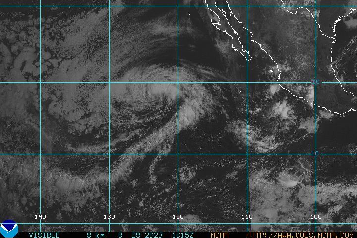
Eastern North Pacific Tropical Weather Outlook |
938 ABPZ20 KNHC 242340 TWOEP
Tropical Weather Outlook NWS National Hurricane Center Miami FL 500 PM PDT Tue Jun 24 2025
For the eastern and central North Pacific east of 180 longitude:
Offshore of Central America and Southern Mexico (EP95): Shower and thunderstorm activity is beginning to show some signs of organization with an area of low pressure located a few hundred miles south of the coast of Guatemala. Environmental conditions appear conducive for gradual development of this system over the next few days, and a tropical depression or tropical storm is likely to form by this weekend while the system moves slowly west-northwestward, roughly parallel to the coast of southern Mexico. * Formation chance through 48 hours...low...30 percent. * Formation chance through 7 days...high...80 percent.
$$ Forecaster Papin |
There are no tropical cyclones at this time. |
No tropical cyclones as of Wed, 25 Jun 2025 04:00:11 GMT |
Atlantic Map
Eastern Pacific Map
|
|