Current Storms
| Description |
|---|
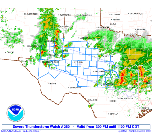
WW 250 SEVERE TSTM OK 292045Z - 300300Z
URGENT - IMMEDIATE BROADCAST REQUESTED
Severe Thunderstorm Watch Number 250
NWS Storm Prediction Center Norman OK
345 PM CDT Fri May 29 2026

The NWS Storm Prediction Center has issued a

* Severe Thunderstorm Watch for portions of
  Northern Oklahoma

* Effective this Friday afternoon and evening from 345 PM until
  1000 PM CDT.

* Primary threats include...
  Scattered large hail and isolated very large hail events to 2
    inches in diameter likely
  Scattered damaging wind gusts to 70 mph likely
  A tornado or two possible

SUMMARY...Thunderstorms have begun to develop in a warm/humid and
unstable air mass.  This activity will track slowly eastward through
early evening, posing a risk of locally damaging wind gusts and
large hail.

The severe thunderstorm watch area is approximately along and 40
statute miles north and south of a line from 50 miles southwest of
Alva OK to 60 miles east southeast of Ponca City OK. For a complete
depiction of the watch see the associated watch outline update
(WOUS64 KWNS WOU0).

PRECAUTIONARY/PREPAREDNESS ACTIONS...

REMEMBER...A Severe Thunderstorm Watch means conditions are
favorable for severe thunderstorms in and close to the watch area.
Persons in these areas should be on the lookout for threatening
weather conditions and listen for later statements and possible
warnings. Severe thunderstorms can and occasionally do produce
tornadoes.

&&

AVIATION...A few severe thunderstorms with hail surface and aloft to
2 inches. Extreme turbulence and surface wind gusts to 60 knots. A
few cumulonimbi with maximum tops to 500. Mean storm motion vector
25025.

...Hart
Read more
|
WW 0250 Status Updates
STATUS FOR WATCH 0250 HAS NOT BEEN ISSUED YETRead more |
MD 0895 CONCERNING SEVERE POTENTIAL...WATCH UNLIKELY FOR FRONT RANGE INTO FAR WESTERN KANSAS
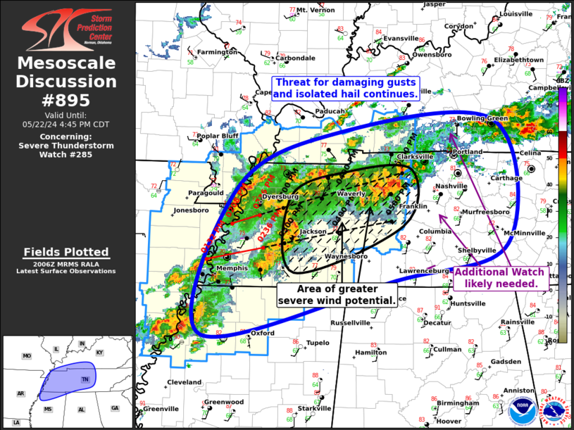
Mesoscale Discussion 0895
NWS Storm Prediction Center Norman OK
0319 PM CDT Fri May 29 2026

Areas affected...Front Range into far western Kansas

Concerning...Severe potential...Watch unlikely

Valid 292019Z - 292215Z

Probability of Watch Issuance...20 percent

SUMMARY...Severe wind gusts are possible into the early evening. A
watch is not expected given limited coverage of severe activity.

DISCUSSION...In the wake of an MCV in northeast Colorado, forcing
for ascent from a shortwave trough pivoting through the eastern
Great Basin has promoted thunderstorms development along parts of
the Front Range into southeast Colorado. These storms have been able
to move off the terrain into the eastern Plains. Outflow production
with these storms is evident. VAD data from KFTG and KPUX show weak
deep-layer shear (around 20 kt). A very well-mixed boundary layer
exists in much of eastern Colorado. Severe gusts will likely be the
primary risk with storms that develop this afternoon. Greater
surface moisture does exist in western Kansas. Some intensification
would be possible if storms can ingest more buoyant air. While large
hail is possible with a discrete storm within the greater moisture,
storm mode by that point may not be very favorable. A brief tornado
could also occur given the presence of the MVC and DCVZ.

..Wendt/Hart.. 05/29/2026

...Please see www.spc.noaa.gov for graphic product...

ATTN...WFO...LBF...DDC...GLD...PUB...BOU...

LAT...LON   38810466 39590478 40300456 40790369 40910314 40880238
            40790214 40220180 38680162 37840193 37540243 37270279
            37170299 37820369 38810466

MOST PROBABLE PEAK TORNADO INTENSITY...UP TO 90 MPH
MOST PROBABLE PEAK WIND GUST...UP TO 60 MPH
MOST PROBABLE PEAK HAIL SIZE...UP TO 1.25 IN
Read more
|
MD 0894 CONCERNING SEVERE POTENTIAL...WATCH POSSIBLE FOR WESTERN/NORTHERN OK INTO PARTS OF THE EASTERN TX/OK PANHANDLES AND EXTREME SOUTHERN KS
Mesoscale Discussion 0894
NWS Storm Prediction Center Norman OK
0316 PM CDT Fri May 29 2026

Areas affected...Western/northern OK into parts of the eastern TX/OK
Panhandles and extreme southern KS

Concerning...Severe potential...Watch possible

Valid 292016Z - 292145Z

Probability of Watch Issuance...60 percent

SUMMARY...Strong to severe storms will be possible from late
afternoon into the evening.

DISCUSSION...Morning convection across parts of northern/central OK
has diminished this afternoon, with relatively strong heating and
destabilization underway across parts of western and northern OK. A
surface confluence zone extends from central into northwest OK, with
the strongest heating noted to the south of this zone across
west-central/southwest OK, and relatively backed low-level flow
observed near/north of this zone. As MLCINH weakens and a compact
midlevel shortwave trough moves from the TX Panhandle into northern
OK, at least isolated storm development will be possible by 4-6 PM
CDT, with some increase in coverage expected into the evening.

Moderate to strong buoyancy will support robust updrafts as storms
mature from late afternoon into the evening. Mid/upper-level flow is
currently rather weak, though some increase is expected into early
evening. Effective shear will be maximized where surface winds
remain backed, and a supercell or two could evolve with time, with a
threat of large to very large hail, localized severe gusts, and
possibly a brief tornado. Outflow consolidation may eventually lead
to a corridor of somewhat greater severe-wind threat across northern
OK and far southern KS. Watch issuance is possible across parts of
the region later this afternoon.

..Dean/Hart.. 05/29/2026

...Please see www.spc.noaa.gov for graphic product...

ATTN...WFO...TSA...ICT...OUN...DDC...AMA...

LAT...LON   35569814 35339875 35219945 35349980 35550018 36270058
            36890080 37209922 37259809 37209717 36729683 36429676
            36059673 35919704 35779764 35569814

MOST PROBABLE PEAK TORNADO INTENSITY...UP TO 90 MPH
MOST PROBABLE PEAK WIND GUST...65-80 MPH
MOST PROBABLE PEAK HAIL SIZE...1.50-2.50 IN
Read more
|
MD 0893 CONCERNING SEVERE POTENTIAL...WATCH UNLIKELY FOR CENTRAL MONTANA
Mesoscale Discussion 0893
NWS Storm Prediction Center Norman OK
0251 PM CDT Fri May 29 2026

Areas affected...Central Montana

Concerning...Severe potential...Watch unlikely

Valid 291951Z - 292145Z

Probability of Watch Issuance...20 percent

SUMMARY...Severe wind gusts along with small to marginally severe
hail may occur this afternoon/evening in central Montana. Storm
coverage is expected to limit a more organized severe wind threat. A
watch is not anticipated at this time.

DISCUSSION...While some MLCIN remains within the plains, convection
continues to develop/deepen on the higher terrain of central
Montana. The 18Z observed Great Falls sounding showed nearly dry
adiabatic mid-level lapse rates. When modifying the sounding for
current surface observations, low-level lapse rates are also
similarly steep. That said, the boundary layer is quite dry and
dewpoints have since mixed down into the upper 40s F. With
additional surface heating, the expectation is for thunderstorms to
move north/north-northeast off of the terrain. Severe wind gusts
will be the primary hazard with this activity. Small hail is also
possible, though a stronger core could produce marginally severe
hail. Storm coverage is uncertain given weak large-scale ascent. Any
greater severe wind threat would be dependent on localized
clustering of storms/outflow.

..Wendt/Hart.. 05/29/2026

...Please see www.spc.noaa.gov for graphic product...

ATTN...WFO...BYZ...GGW...TFX...

LAT...LON   46181131 47061205 48531217 49061133 49070964 48690859
            47920857 46330918 46181131

MOST PROBABLE PEAK WIND GUST...65-80 MPH
MOST PROBABLE PEAK HAIL SIZE...UP TO 1.25 IN
Read more
|
MD 0892 CONCERNING SEVERE POTENTIAL...WATCH UNLIKELY FOR PORTIONS OF THE NORTHERN ROCKIES
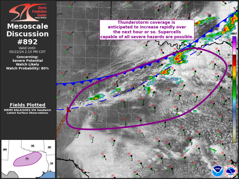
Mesoscale Discussion 0892
NWS Storm Prediction Center Norman OK
0230 PM CDT Fri May 29 2026

Areas affected...Portions of the northern Rockies

Concerning...Severe potential...Watch unlikely

Valid 291930Z - 292130Z

Probability of Watch Issuance...20 percent

SUMMARY...Scattered storms may produce isolated large hail and
severe winds this afternoon into the early evening. A watch is not
currently anticipated.

DISCUSSION...Convection continues to increase within the higher
terrain of western Montana. A few thunderstorms have also developed
within the last hour. A belt of southerly upper level winds is
promoting around 30 kt of effective shear per the KMSX VAD.
Temperatures may remain a bit on the cool side, especially now that
anvil clouds are spreading north. Some locations of northwest
Montana may be able to warm further by late afternoon. Overall, 1000
to perhaps near 1500 J/kg MLCAPE can be expected. Given the low 50s
F dewpoints within the higher terrain, scattered storms are
probable. This may lead to numerous storm interactions since the
deep-layer shear is somewhat marginal. The strongest storms will be
capable of large hail and severe wind gusts this afternoon/early
evening.

..Wendt/Hart.. 05/29/2026

...Please see www.spc.noaa.gov for graphic product...

ATTN...WFO...TFX...MSO...OTX...

LAT...LON   45501444 46391518 47931512 48631412 48881366 49061327
            49001286 48651253 46441193 46031223 45501444

MOST PROBABLE PEAK WIND GUST...65-80 MPH
MOST PROBABLE PEAK HAIL SIZE...UP TO 1.25 IN
Read more
|
MD 0891 CONCERNING SEVERE POTENTIAL...WATCH POSSIBLE FOR PARTS OF THE TX SOUTH PLAINS/PERMIAN BASIN VICINITY
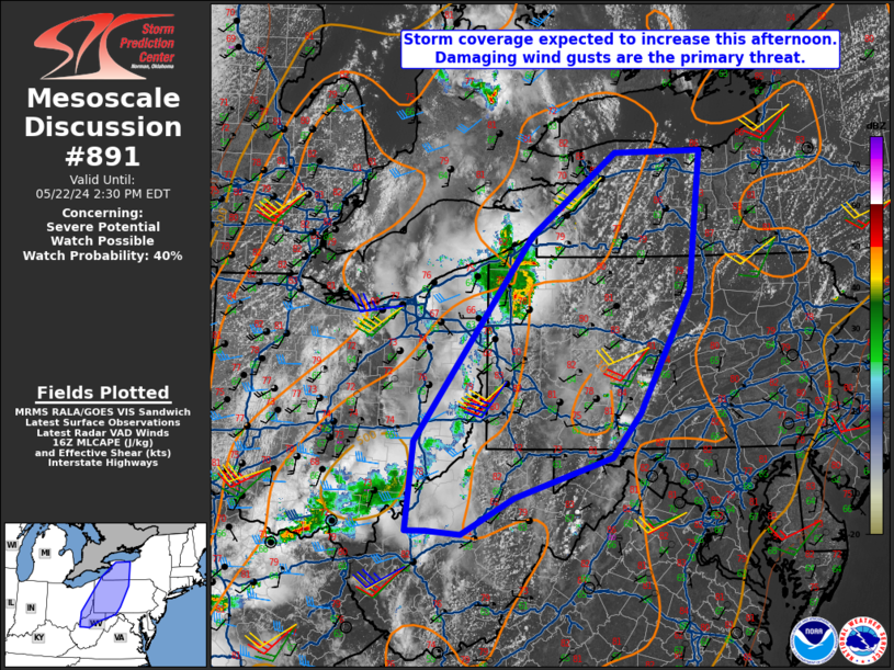
Mesoscale Discussion 0891
NWS Storm Prediction Center Norman OK
0229 PM CDT Fri May 29 2026

Areas affected...Parts of the TX South Plains/Permian Basin vicinity

Concerning...Severe potential...Watch possible

Valid 291929Z - 292130Z

Probability of Watch Issuance...60 percent

SUMMARY...Severe storms may develop by 4-5 PM CDT, with a threat of
hail and severe gusts. Watch issuance is possible.

DISCUSSION...Relatively strong heating is underway across parts of
west TX this afternoon, though some areas of mid/upper-level clouds
persist. Low-level south/southeasterly flow to the east of a weak
surface trough is maintaining sufficient low-level moisture for
moderate destabilization, with MLCAPE increasing to near/above 1500
J/kg across parts of the TX South Plains and Permian Basin.
Decreasing CINH and a subtle midlevel shortwave trough near the
TX/NM border will support scattered thunderstorm development by late
afternoon. An approaching mid/upper-level subtropical jet maximum
will lead to strengthening deep-layer shear (with effective shear of
40+ kt), and a few organized cells or clusters may evolve with time.

Isolated large hail will be possible, including conditional
potential for 2+ inch diameter hail if any sustained supercells
develop. Relatively deep mixing and steep low-level lapse rates will
encourage increasing outflow with time, with an attendant threat of
at least isolated severe gusts (potentially 75+ mph). Issuance of
one or more watches is possible later this afternoon in order to
address these threats.

..Dean/Hart.. 05/29/2026

...Please see www.spc.noaa.gov for graphic product...

ATTN...WFO...SJT...LUB...AMA...MAF...

LAT...LON   31070288 33830259 34450152 35080070 35030044 34910009
            34260022 33080065 30990130 30340181 30390256 30590282
            31070288

MOST PROBABLE PEAK TORNADO INTENSITY...UP TO 90 MPH
MOST PROBABLE PEAK WIND GUST...65-80 MPH
MOST PROBABLE PEAK HAIL SIZE...1.50-2.50 IN
Read more
|
SPC 2000Z Day 1 Outlook
 Day 1 Convective Outlook NWS Storm Prediction Center Norman OK 0256 PM CDT Fri May 29 2026 Valid 292000Z - 301200Z ...THERE IS A SLIGHT RISK OF SEVERE THUNDERSTORMS OVER WEST TEXAS INTO WESTERN OKLAHOMA... ...SUMMARY... Scattered strong to severe storms capable of sporadic large hail and scattered severe winds are still expected this afternoon and evening across portions of western Texas into northern Oklahoma. More isolated severe thunderstorms remain likely across parts of the central High Plains, southern Utah, and the northern Rockies. ...20Z Update... The previous forecast (see below) remains generally on track. The biggest change made to the outlook was to extend 15 percent wind and hail probabilities (hence the Slight risk) farther east into OK. Though speed and directional shear are not expected to be overly abundant, some hodograph curvature and elongation, amid 2500-3000 J/kg MLCAPE will support multicells and transient supercells capable of producing severe wind and hail (with a few stones potentially exceeding 2 inches in diameter). Otherwise, more minor adjustments were made to thunder and severe probabilities to account for observations and the latest guidance consensus. ..Squitieri.. 05/29/2026 .PREV DISCUSSION... /ISSUED 1110 AM CDT Fri May 29 2026/ ...Southern Plains... Southwesterly flow aloft is present today over AZ/NM, with large scale height falls and weak ascent overspreading west TX/OK. Low-level southeasterly flow in this region is maintaining a moist and potentially moderately unstable air mass, with breaks in the clouds leading to pockets of CAPE over 2000 J/kg. By late afternoon, clusters of thunderstorms will develop from the Davis mountains northward into the TX Panhandle. Forecast soundings in this area show a deeply mixed boundary-layer suggestive of a damaging wind and large hail potential. These storms will congeal and move eastward into western OK during the evening, spreading into greater low-level moisture and CAPE profiles. The risk of hail may increase as this happens. ...Northeast CO/Northwest KS... Scattered afternoon thunderstorms are expected to develop along the Palmer Ridge to the east of Denver, and over the plains of southeast CO. These storms will track northeastward through the early evening, with some increase in low-level shear expected. This may result in a supercell or two capable of large hail, damaging winds, or perhaps a tornado. ...MT... A consensus of 12z model guidance continues to show that scattered afternoon thunderstorms will form over the terrain of western and central MT. This activity will spread northward toward the Canadian border, through a region of 1000 J/kg CAPE and a deeply mixed boundary-layer. This would support a risk of isolated damaging wind gusts and perhaps hail in the strongest storms.Read more |
SPC 1730Z Day 2 Outlook
 Day 2 Convective Outlook NWS Storm Prediction Center Norman OK 1224 PM CDT Fri May 29 2026 Valid 301200Z - 311200Z ...THERE IS A SLIGHT RISK OF SEVERE THUNDERSTORMS FOR WESTERN NEBRASKA INTO SOUTHWEST SOUTH DAKOTA... ...SUMMARY... Thunderstorms with large hail and severe wind gusts are expected on Saturday from parts of western and central Nebraska into southern and western South Dakota. Isolated severe gusts and hail will also be possible in the northern High Plains, and from parts of the central Plains into the southern High Plains. ...Synopsis... A mid-level shortwave trough will rotate from the Rockies into the central Plains on Saturday as a lee surface cyclone develops across western Kansas. A dryline will mix eastward across southwest Kansas into the Texas Panhandle. ...Western Nebraska into southwest South Dakota... A dryline will bend northwestward from central Kansas into the Nebraska Panhandle on Saturday afternoon. As the mid-level trough overspreads the region, inhibition will erode and storms are expected to develop by mid-afternoon. Most guidance shows some mixing of the shallow moisture across the region during the afternoon. This casts some uncertainty on storm coverage across far southern Nebraska and into northern Kansas. However, farther northwest, where mid-level forcing will be stronger, storms are anticipated across the Nebraska Panhandle into southwest South Dakota. Large hail and damaging wind gusts will be the primary threat from this activity. It is worth noting, that some guidance which is a bit more progressive with northwestward moisture transport would be more supportive for a tornado threat across the region. However, this appears to be a more outlier solution rather than a likely solution. Therefore, the 2% tornado probabilities seem appropriate. ...Kansas to West Texas... Isolated storm development is possible along the dryline from West Texas to central Kansas Saturday afternoon. Upper level forcing will be focused farther north and convergence will be weak along the dryline from the Kansas/Oklahoma border southward. In addition, shallow moisture is forecast to mix out ahead of the dryline. However, despite these mitigating factors, strong surface heating is expected which would result in a mostly uncapped airmass along the length of the dryline. 30 to 40 knots of mid-level flow is expected to remain across the region which could result in a supercell or two. A more concentrated zone of storms may exist from southern Kansas into central Kansas, closer to the upper-level forcing, where convergence along the dryline is also greater. However, within this zone, shear may be marginal (20 to 25 knots) within a relatively weak area of mid-level flow. Therefore, higher probabilities have not been added. ...Western Missouri... Within a zone of weak isentropic ascent Saturday night and early Sunday morning, strong to isolated severe storms may develop from far eastern Kansas into western Missouri. A few storms may be capable of large hail. ..Bentley.. 05/29/2026Read more |
SPC 1930Z Day 3 Outlook
 Day 3 Convective Outlook NWS Storm Prediction Center Norman OK 0155 PM CDT Fri May 29 2026 Valid 311200Z - 011200Z ...THERE IS A MARGINAL RISK OF SEVERE THUNDERSTORMS FROM THE NORTHERN PLAINS TO THE OZARKS... ...SUMMARY... Thunderstorms with hail and isolated severe gusts will be possible on Sunday from parts of the lower to mid Missouri Valley into the central and northern Plains. ...Synopsis... Mid-level ridging will build across the central portion of the CONUS with a deepening trough moving from Quebec into the Northeast on Sunday. A broad, weak surface trough will extend from the central Plains to the northern Plains. A moist environment will exist ahead of this trough with dewpoints in the upper 60s to low 70s. ...Northern Plains into the Central Plains and Ozarks... A frontal zone is forecast to extend from the northern Plains to the Midwest Sunday morning. South of this boundary, moderate to strong instability is forecast to develop amid upper 60s to low 70s dewpoints. Despite the strong instability along this frontal zone, convective development (particularly strong storm development) remains uncertain given strong height rises expected across the region beneath the building ridge. However, if storms are able to develop, 25 to 30 knots of effective shear should be sufficient for storm organization and perhaps some rotating updrafts. Large hail and damaging winds will be the primary threats. ...West Texas to western Oklahoma... Storms are expected to develop across West Texas Sunday afternoon amid moderate instability. However, very weak mid-level flow will be present across the region which will likely lead to storm mergers and relatively quick upscale growth into a likely non-severe MCS. Given the steep lapse rates across the area, some isolated severe wind gusts may occur, particularly early in storm lifecycles. This potential does not appear large enough for 5 percent probabilities at this time. ..Bentley.. 05/29/2026Read more |
SPC Day 1 Fire Weather Outlook
 Day 1 Fire Weather Outlook NWS Storm Prediction Center Norman OK 1133 AM CDT Fri May 29 2026 Valid 291700Z - 301200Z ...Morning Update... No changes were made to the ongoing forecast. As the upper trough lifts over the Four Corners and Colorado Plateau this afternoon, dry southerly flow will continue to dominate meanwhile large scale ascent and increasing mid-level moisture will allow a threat of thunderstorms to form. Current surface observations depict widespread RH of less than 30% across the region, owing to poor overnight recoveries. At peak heating, sustained southerly winds of 15-25 mph (locally higher) with gusts up to 40 mph and RH values of 15-20% will overspread dry fuels, maintaining Elevated fire weather concerns. Localized critical conditions may emerge in terrain-favored areas where sustained winds exceed 25 mph and RH nears 10%. See the previous discussion for more information. ..Elizalde-Garcia.. 05/29/2026 .PREV DISCUSSION... /ISSUED 0150 AM CDT Fri May 29 2026/ ...Synopsis... The closed mid-level low across the western CONUS will open up and lift northeast from southern Nevada/California into the central Rockies. As this occurs, a mid-level jet streak located in the basal region of the trough will traverse the Southwest, Four Corners, into central Colorado. ... Colorado Plateau and Southwest ... Strong diurnal heating of a dry atmosphere will support afternoon relative humidity to fall into the teens across the region. At the same time, the mid-level jet streak will be overhead. As the boundary layer deepens beneath this jet streak, strong vertical mixing will result in strong, gusty winds reaching the surface, perhaps locally as high as 25-30 mph. Receptive fuels across the area will combine with meteorological conditions to support a few hours of elevated to locally critical fire weather conditions during the afternoon. Additionally, deep boundary layer circulations, coupled with large-scale ascent and increasing mid-level moisture associated with the passing trough, will support some thunderstorm potential across portions of northern Arizona, central and eastern Utah, and western Colorado. Given receptive fuels and a dry atmosphere (as measured by precipitable water values generally at or below 0.5 inches) will support at least some potential for dry thunderstorms, especially given average forecast storm speeds around 30 knots. ...Please see www.spc.noaa.gov/fire for graphic product...Read more |
SPC Day 2 Fire Weather Outlook
 Day 2 Fire Weather Outlook NWS Storm Prediction Center Norman OK 0205 PM CDT Fri May 29 2026 Valid 301200Z - 311200Z ...NO CRITICAL AREAS... ...Afternoon Update... As a shortwave trough lifts into the High Plains, induced lee cyclogenesis will tighten surface pressure gradients east of the Rockies. A dryline will emerge and sweep over the TX/OK Panhandles, driving downslope flow across the southern Plains. The overall pattern would otherwise enhance broader elevated to critical fire weather concerns if recent precipitation had not mitigated fuel receptivity. However, very isolated areas that did not receive appreciable rainfall may experience locally elevated fire weather conditions as westerly 15-25 mph winds and 10-15% RH overspread the southern Plains landscape. ..Elizalde-Garcia.. 05/29/2026 .PREV DISCUSSION... /ISSUED 0150 AM CDT Fri May 29 2026/ ...Synopsis... A mid-level trough over the central Rockies at the start of the forecast period will slowly lift north toward the northern Rockies during the forecast period. This will place much of the Southwest into Central US in broad southwest flow, between a Pacific Northwest trough and a Gulf mid-level ridge. Despite the favorable mid-level pattern configuration for fire weather concerns, the overall flow appears too weak across areas with receptive fuels and fuels appear to be unreceptive across areas with stronger flow. Thus, large-scale fire weather concerns look to be minimal across the CONUS on Day-2/Saturday. ...Please see www.spc.noaa.gov/fire for graphic product...Read more |
Thunder Storms Outlook

Tornado Outlook

Hail Outlook

Wind Outlook

Rowlo
Copyright © 2003-2025 by Jeff Rowland
All Rights Reserved.
Site Design: Jeff Rowland